General Climate
Like many semi-arid watersheds in the southwestern U.S., the Beaver Creek watershed exists within a climatic regime that brings cyclic weather patterns. The general and somewhat predictable pattern begins with a dry fall followed by winter precipitation that originates in the Pacific Northwest. At higher elevations, this low-intensity, regional precipitation is often in the form of snow. Snow is important to the hydrological regime in the Mogollon Rim area, providing spring runoff and streamflow, and facilitating downward infiltration of water into aquifer units at higher elevations. It is difficult to predict if and when winter storms will occur, and though winter precipitation averages about 11 inches, it can be as little as 2 or 3 inches. When winter precipitation ceases early in the season or is largely absent, the ensuing spring is unusually dry, with highly volatile vegetation that is especially fire-prone. Spring's higher temperatures and high velocity winds can be devastating to vegetation that has had to withstand an unusually dry winter.
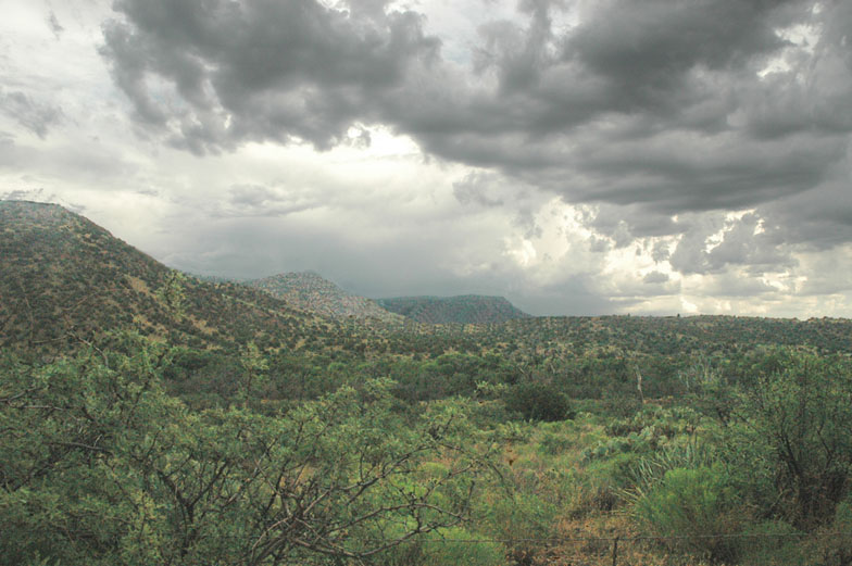
A summer monsoon developing over the Beaver Creek watershed
Following a spring that is typically (though not always) quite dry, summer monsoon thunderstorms bring much needed rain. These high-intensity, local thunderstorms are capable of dropping up to 3 inches of rain within as little as 30 minutes (Baker 1982). They originate in either the Gulf of Mexico or the Sea of Cortez and typically begin in early July, lasting through early to mid-September. Monsoon storms can cause flash floods in stream channels and lightning strike fires in vegetation. Though the time of occurrence varies, the timing of these storms is much more predictable than that of winter storms in the area.
Climate and Elevation
At higher elevations where the ponderosa pine proliferate, annual precipitation levels range from 20 to 30 inches in a normal year. The majority of surface runoff in these areas comes from winter precipitation, while only a small amount of summer precipitation contributes to streamflow. Transpiration rates are high (about 20 inches per year) in the pine types throughout the watershed and low soil moisture content is common.
At moderate elevations where the pinyon-juniper woodlands proliferate, annual precipitation levels range from 12 to 24 inches in a normal year. Evapotranspiration rates are high, at about 16 inches per year and the months of December through February being the only months when precipitation is greater than evapotranspiration. Since little water is believed to contribute to groundwater flow in the watershed, evapotranspiration rates are usually considered to equal the difference between annual precipitation and streamflow.
The climate of the Beaver Creek Watershed (BCW) mirrors the climate of Domain 13, based on an analysis of 800m PRISM data. Climate data summarized in Table 2 shows that the mean climate and elevation values for the BCW are remarkably close to those of Domain 13. The seasonality of precipitation in the Intermountain West is thought to be equally important as total precipitation. The proportion of annual average precipitation received during the monsoon season (from high to low elevation sites in the watershed) brackets that of Domain 13, underscoring how well it is able to represent Domain 13 in terms of seasonal moisture receipt (See Table 2 and Figure 2).
Click here for more detailed information on the Beaver Creek Watershed's climate
Table 2. Climate and elevation characteristics for Domain 13 and the Beaver Creek Watershed (PRISM Group, 2004). Note: the proposed BioMesoNet Tower sites are located in the high elevation portion of the watershed.

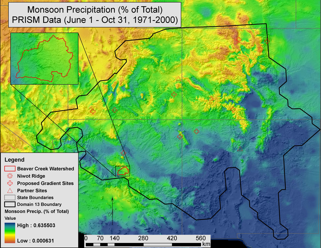
Figure 2. The Beaver Creek Watershed ranges from low-moderate to high monsoon precipitation receipt, making it an ideal location for detecting the affects of climate change on monsoonal patterns.
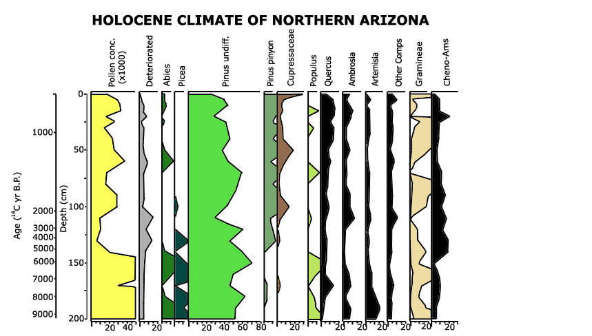
9000 years of climate change as evidenced by vegetation change
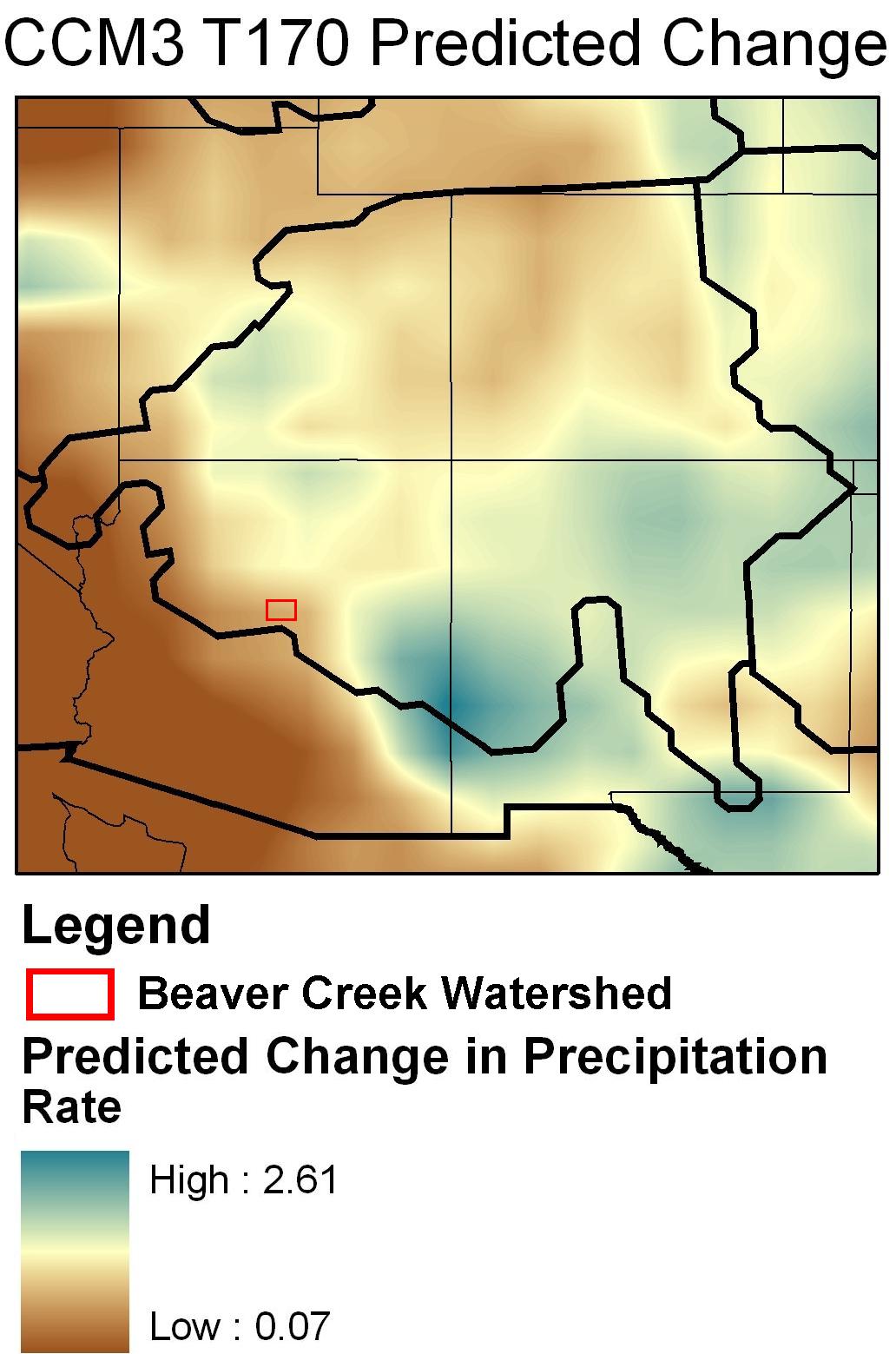
The Beaver Creek Watershed (BCW) is an ideal location to monitor the ecological impacts of climate-change because of its pronounced elevation gradient and its geographic location within the region. Elevation gradients, such as the one found in the BCW, are sensitive sentinels for detecting the differential effects climate-change. Climate-change has the potential to alter the structure, composition, and function of forest ecosystems. In northern Arizona, climate-change is predicted to increase the frequency and intensity of drought. The BCW is located near the northern extent of monsoonal precipitation, and thus, in combination with other sites inside and outside of Domain 13, would contribute to NEON's ability to detect and document such climate-change impacts. See Figure 6 below for predicted change in precipitation with doubled atmospheric CO2 concentrations. A proposed NEON Research Design titled: Climate-change: Evaluating Ecosystem Responses to Warming, Drought, Snowpack Disappearance, and Changing Fire Regimes at Regional-to-Continental Scales addresses this important research challenge. This research design proposes to further develop a predictive understanding of the responses terrestrial ecosystems are having to climate variability and climate-change at local, regional and continental scales. These research objectives are closely aligned with those of ongoing and planned research being conducted by scientists at Northern Arizona University and partner organizations.
Northern Arizona University is one of four regional centers managing and coordinating the National Institute for Climatic Change Research ( NICCR). This Institute is sponsored by the U.S. Department of Energy's (DOE's) Office of Biological and Environmental Research (BER). The goal of NICCR is to mobilize university researchers, from all regions of the country, in support of the climatic change research objectives of DOE/BER. The scientific research topics being pursued by the NICCR are (a) the effects of potential climatic changes on important U.S. terrestrial ecosystems and (b) potential feedbacks from U.S. terrestrial ecosystems to the climatic system. Climate-change research on the nearby elevation gradient of the San Francisco Peaks is an example of research that has recently been funded by NICCR. This project intends to improve modeling for climate-change impacts by merging biogeographical/habitat models with dynamic vegetation modeling, and by merging climate modeling with ecosystem modeling. In addition, ongoing research will transplant micro-ecosystems consisting of grasses and soil down the elevation gradient of the San Francisco Peaks to simulate and assess changes in temperature expected with doubled atmospheric CO2 concentrations. The experiment will include various watering treatments to simulate the range of possible changes in precipitation associated with climate-change. Previous research conducted
along this same elevation gradient has better informed how different tree species
have responded to past variation in climate, including drought. A better understanding
of species' past responses to climate-change provides crucial insight into potential
future responses to climate-change. Regional drought in the last nine years is
rapidly and dramatically altering Southwest ecosystems. The drought has become
a catalyst, bringing researchers and land managers together to assess drought
impacts. DIREnet enables researchers to address specific questions that can not be addressed without effective pan-regional coordination. These and other ongoing climate-change related research endeavors provide legacy data and models for future climate-change research in the Beaver Creek Watershed. The geographic location, pronounced elevation gradients and wealth of local expertise in the climate-change arena make Beaver Creek and the nearby San Francisco Peaks attractive places to further NEON's climate-change research agenda.
|