Beaver
Creek Geology | Soils
Geology
Publications | Geologic
Map | Soils
Map
Beaver Creek Geology
Geologic
Setting
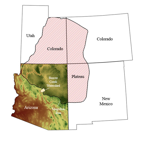
The Beaver Creek
Watershed is located within
the Colorado
Plateau physiographic province, at the southern edge
of the Plateau.
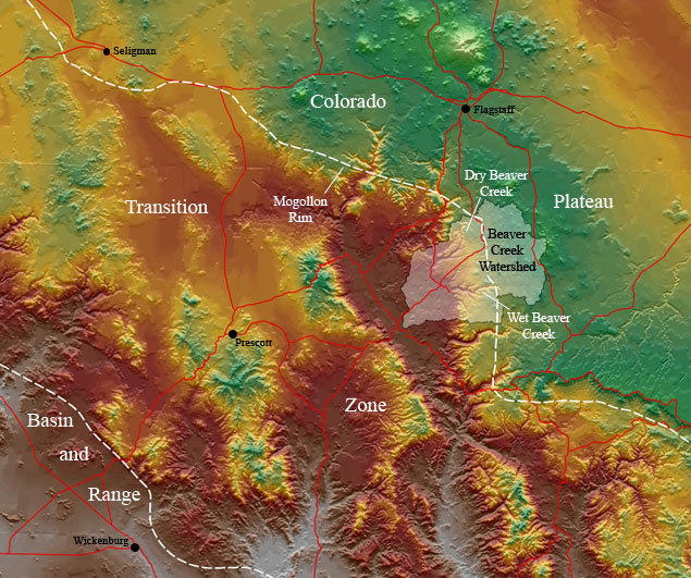
The watershed is one of many that dissect the Mogollon Rim, the landform that
separates the Colorado Plateau from the topographically lower Verde Valley .
The Mogollon Rim has been interpreted by Thompson (1968) to be at least a partly erosional escarpment (steep cliff) that
formed following the uplift of the Colorado Plateau, which began
approximately 70 million years ago and continued episodically
through about 20 million years ago. The Mogollon Slope is
the regional landform that makes the transition
from the Rim to the Valley. The regional dip of
the Mogollon Slope is generally toward the northeast
in most places; however, the Mormon Mountain anticline
(a flexure, or bend, in the earth's crust) causes
the slope to dip toward the southwest in the Beaver
Creek area (Baker, 1982). Accordingly, Beaver Creek flows generally west-southwest
along the slope until it reaches the southeast-flowing
Verde River, of which it is a major tributary.
The Mormon Mountain anticline also
serves as a watershed boundary between the regional Colorado
River and Verde River Watersheds. The Verde Valley
lies within Arizona's Transition
Zone,
a region characterized by extension (stretching) of the
earth's crust along low-angle faults that expose
older, deep-crustal rocks. This Zone transitions
into the Basin and Range Province, a region dominated
by crustal extension along high-angle faults,
resulting in alternating basins and ranges. Extension in
the Transition Zone and the Basin and Range Province
occurred contemporaneously with later uplift
of the Colorado Plateau during the late Tertiary Period.
It is not known why the Plateau remained relatively
intact amidst this tectonic activity.
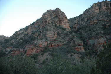
Limestone beds, presumably of the Kaibab Formation (beige), above either upper Toroweap Formation or Coconino Sandstone (red-brown), Wet Beaver Creek Canyon
Rocks
The rocks in the Beaver Creek watershed include
volcanic and sedimentary rocks that vary in age (see Geologic
Map of the Beaver Creek Watershed). The sedimentary
rocks are a combination of Paleozoic, Mesozoic, and Tertiary
ages, but among the most notable are the Tertiary volcanic rocks
(click here to view Geologic
Time Scale). The Tertiary volcanics overlie
older, late Paleozoic
fractured--and, therefore, porous and permeable--units
that serve as both water conduits and as underground water
reservoirs. The variable porosity and permeability
of the volcanic units determine whether precipitation and
runoff infiltrate the regional water table, which is estimated
to be anywhere from 300m to 600m below the surface (the
exact depth varies from one location to the next).
Structures
The structural grain, or dominant trend of structures, in the Beaver Creek area is northwest-southeast. Thompson (1968) inferred that the northeast trend of Beaver Creek and adjacent creeks suggests a secondary, northeast-southwest structural trend, but he noted that definitive evidence for such a trend is obscured by the overlying volcanic rocks. Thompson also noted that several northwest-trending faults dissect the Beaver Creek drainage. Furthermore, he interpreted the Mogollon Rim escarpment to be at least partly erosional, since he was not able to observe distinct fault surfaces along the Rim. This implies that structural control is present, but is not always the rule in this area.

