Hydrology | Groundwater | Surface Water
Hydrology Publications | Experimental Watershed | Watershed Map
Beaver Creek Experimental Watershed
History
Introduction
Time Line and Location
Databases
Summary
History Behind the Experiments
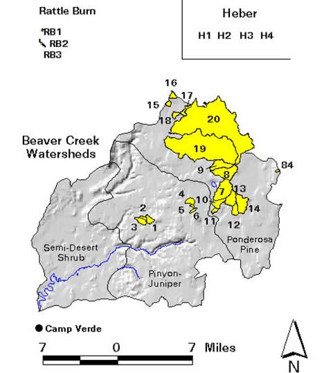
The Beaver Creek Experimental Watershed evolved out of a series of events that began in 1955 when ranchers and other southern Arizona water users expressed concern to the U.S. Forest Service that growing numbers of plants and shrubs on Forest Service lands were threatening grazing lands and water resources. The Forest Service, based on the findings of the Barr Report that was subsequently commissioned by the University of Arizona, began to test theories for increasing streamflow by about 1960. The Beaver Creek Watershed Evaluation Program was intended to determine how much water yield could be increased by altering vegetation. Changes in livestock forage, timber production, wildlife habitats, recreational uses, and soil movement also were to be studied.
Introduction to the Experiments
Over the next few years, the Beaver Creek watershed was divided into 20 watershed subunits in which various vegetation managment practices were to be tested for their impact upon water yield and other resources. 18 of the watershed subunits ranged from 66 to 2,036 acres, while the two remaining were 12,100 and 16,500 acres, respectively. These two latter subunits were intended to represent areas the size of which forest managers typically work with. Another 24 subunits have recently been added to the study to expand the database of information from which managers conduct analysis and make decisions.
Three different types of treatments were applied to the trees and shrubs prior to seeding with various grass types: uprooting, herbicide spraying, and cutting. Uprooting is the most common method, since the use of herbicides is limited by federal standards. The following table and figure, borrowed from the U.S. Forest Service Rocky Mountain Research Station website, briefly summarize the type of data collected within the watershed subunits.
back to top
Time Line and Location of Data
Database
Use this link to an online database provided by the Rocky Mountain Research Station to access data obtained through the Beaver Creek Experimental Watershed program.
back to top
Summary of Results
The results of studies within the Beaver Creek watershed have shown that water yield increases in pinyon-juniper areas are not likely to be as significant as they had previously been believed to be. Increased grass is the most noticeable change triggered by pinyon-juniper removal. However, the cost of removal usually is more than the value of the livestock forage gained.
Pinyon-juniper removal also causes wildlife changes, particularly among small mammals and birds. For example, birds that feed in trees are replaced by ground feeders. Pinyon-juniper removal did not seem to affect the mule deer, but this was attributed to the availability of additional forage in early spring, when mule deer are often in need of it.
Records from the pinyon-juniper watersheds show that erosion rates and sediment loads in the streams have varied sharply with the intensity of storms. A heavy storm soon after the trees were removed from one watershed washed away much of the soil. In the long run, however, average sediment loads from the treated watersheds did not exceed those from the control watersheds significantly.
In one subunit, herbicide residues found in small amounts in streamflows the year following application soon disappeared. In three subunits, changes in water quality were minor.
back to top