We propose locating the Advanced BioMesoNet Tower System in an unmanaged ponderosa pine stand, in the upper part of the watershed. An experimental BioMesoNet Tower could be located within 1 km of the advanced tower. The three additional basic BioMesoNet Tower Systems will be located down the elevation gradient from the ponderosa pine forest, through the pine-oak forest, and will terminate at the ecotone with the pinyon-juniper woodland. This placement of instrument towers will allow documentation of changes in climate factors over the entire range of dominant forest vegetation in the Beaver Creek Watershed, and will include key ecotones where effects of changing climate can be compared among co-occurring species (Adams and Kolb 2004, 2005).
There are no homeland security or airspace restrictions of concern in the area. Restrictions on use would be those imposed by the USFS and the
National Environmental Protection Act (NEPA) process. Because NEON core site use is compatible with the USFS planning for the watershed and because we have avoided areas of particular environmental (
Figure 2) or cultural concerns, there should not be any onerous restrictions on research use. The Advanced BioMesoNet site is 69 highway kilometers plus 3.3 km dirt road miles from Flagstaff, AZ. Flagstaff has a commercial airport. There are five grazing allotments within the watershed; one of the larger allotments is provided to the V-V Ranch (
Figure 3), which is owned and operated by the University of Arizona. The grazing allotment for the proposed Advanced BioMesoNet Tower site is held by the Bar D Cattle Company. The Coconino National Forest has consistently allowed fenced exclosures for the purpose of research within lands under grazing leases. The site is near a power transmission line easement (
Figure 2). There are several potential sites near the site marked on the maps that also meet NEON core site criteria. The various sites have tradeoffs of distance to power transmission lines, number of miles of dirt road access, and degree of waterway access. All potential sites have large enough areas with less than five degrees slope for the location of a flux tower.
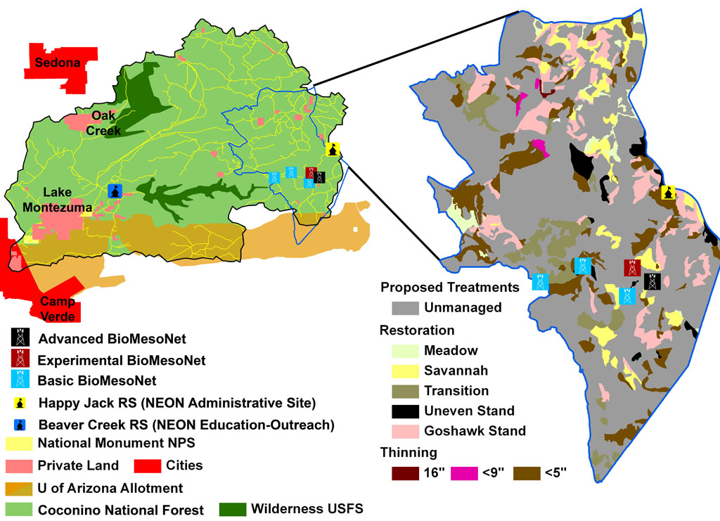 Figure 3 . Beaver Creek Watershed (Left) highlighting land ownership and key NEON locations. The Uof A owns the V-V ranch in the lower part of the watershed. The expanded portion depicted on the right shows the location of the BioMesoNet Towers and proposed USFS restoration and thinning treatments.